LITTLE ROCK, Ark. (AP) – Floodwaters that killed 20 people at a remote Arkansas campground last year reached about 7 feet deep in the nearby floodplain and flowed at speeds up to 7.5 mph, according to a report released Wednesday by the U.S Geological Survey.
“You couldn’t stand up in it, and it was flowing pretty fast,” said Robert Holmes, a national flood specialist who was a co-author of the report about the deadly flood at the Albert Pike Recreation Area in southwest Arkansas.
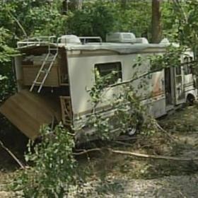
Seven children and 13 adults died in the flooding, which came when a storm system dumped a tremendous amount of rain on the remote valley in the Ouachita Mountains early on June 11, 2010. As much as 4.7 inches of rain fell in three hours in the upper Little Missouri River watershed.
Worried forecasters sent warnings four times in a single hour to advise people of the potential for flash flooding. But those warnings, issued in the middle of the night, never reached vacationing families in the remote campground in the floodwaters’ path. The camp had no ranger on-site, no cell phone service and no sirens, and deputies at the nearest sheriff’s departments were at least an hour’s drive away.
Those who died were from Arkansas, Louisiana and Texas. The flash flood also tumbled over recreational vehicles and ripped away tents.
After the flood, the U.S. Forest Service said officers would drive into the campground during bad weather and warn people that the river could flood. Since there wasn’t a stream gage to measure the depths and flows of the stream at the campground, the U.S. Geological Survey sent a team of scientists to study the flow and height of the water. They used high-water markings and the contours of the land to determine depths and speeds of the flood at the campground.
At Albert Pike, the peak flow for the Little Missouri River was 40,100 cubic feet per second, the report said.
“As narrow as that stream is, that’s a lot,” said John Robinson, a meteorologist with the National Weather Service office at North Little Rock.
About nine miles downstream, at a stream gage near Langley, Ark., water was flowing at about 70,800 cubic feet per second. In comparison, the U.S. Army Corps of Engineers issues small craft advisories at 70,000 on the Arkansas River, which is a much larger body of water.
©2011 Associated Press. All rights reserved. This material may not be published, broadcast, rewritten, or redistributed.