LITTLE ROCK, Ark. – March 1-7, 2020 has been declared Severe Weather Awareness Week by the National Weather Service (NWS) and Arkansas Department of Emergency Management (ADEM). Today’s topic of discussion will be on watches and warnings.
When severe weather is in the forecast, it’s important to know the difference between critical weather terminology and what you should do for each scenario.
Let’s start with where and why general severe weather watches are issued:
When conditions are favorable for severe weather, the SPC, Storm Prediction Center, will issue a watch, either tornado or severe thunderstorm based on the conditions at play. It will be issued in collaboration with the local National Weather Service that is impacted by the watch.
A tornado or a severe thunderstorm warning is issued by the local National Weather Service office.

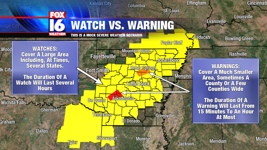
The appearance of watches and warnings on a map:
A severe thunderstorm or tornado watch will cover a large area and can even include multiple states. The duration of a watch can last around 6 hours.
When a severe thunderstorm or tornado warning is issued, they are much smaller and only cover a county or a few counties at one time. The duration of a warning can last from 15 minutes to at most an hour.
Severe Thunderstorm/Tornado Watch vs. Warning Terminology:
A Severe Thunderstorm Watch means that conditions are favorable for a severe thunderstorm that is capable of producing straight-line wind gusts of 58 mph or greater, quarter size hail or larger, and/or a tornado.
- Preparations: review your severe weather safety plan, and make sure you’re staying weather-aware throughout the day.
A Severe Thunderstorm Warning means that a thunderstorm is capable of producing any of the conditions above at any moment or is producing any of them right now.
Now you might be wondering why would a severe thunderstorm warning be issued with tornado wording? Severe thunderstorms are already rotating aloft which helps produce wind and large hail. If the rotation appears to be tightening (a sign of tornadic potential) that wording can be used. The rotation may only last a few minutes before weakening but during that time a brief spin-up might have occurred. That is how the use of the word, tornado, can be used under a severe thunderstorm warning. If the rotation continues to tighten or stays tightened for much longer, the National Weather Service will likely issue a tornado warning.
- Take action: seek shelter immediately.
A Tornado Watch means that conditions are favorable for the development of a tornado, but it does not mean that a tornado is on the ground.
- Preparations: review your severe weather safety plan, and make sure you’re staying weather-aware throughout the day.
A Tornado Warning means that a tornado has been sighted or has been indicated on radar. Danger may be imminent.
- Take action: seek shelter immediately.
The term Tornado Emergency is reserved for rare situations in which a tornado has been spotted visually or radar strongly suggests the ongoing destruction of a tornado (debris ball signature indicating debris being lofted into the air, picked up on radar technology). The NWS uses this term when there is a severe threat to human life and catastrophic damage is likely ongoing.
- Take action: seek shelter immediately.


