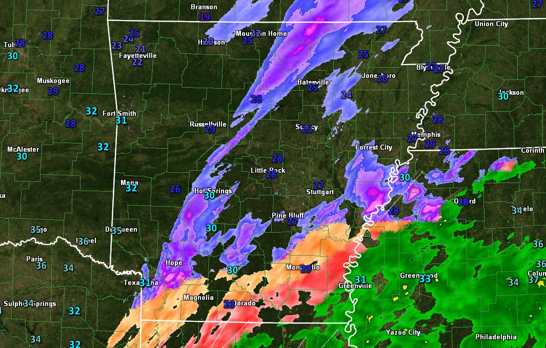
A storm system passing through Louisiana is spreading some moisture into some very cold air across Arkansas today. Freezing rain is falling across Southern Arkansas, mainly South of Monticello and Camden. Some light sleet and snow pellets is falling across parts of Central Arkansas, although accumulations are not expected. Send your winter weather pics to news@fox16.com or use the FOX16 News or Weather apps. Below is the radar and temperatures as of 11 AM Monday
The red areas indicate mainly freezing rain, with the purple mostly sleet or snow pellets. Much of the precipitation indicated on radar over Central and Northern Arkansas is very light or not reaching the ground at all due to dry air. Temperatures over Southern Arkansas are in the upper 20s to near 30 with steady rain causing icing in some spots. The greatest threat for icing is over Ashley and Chicot Counties in Southeast Arkansas where the National Weather Service has issued an ice storm warning.
Enough icing may occur in the warning area that travel will become dangerous, as well as ice buildup on trees and power lines is likely. Power outages are possible in the warning area with more than a quarter inch of ice accumulation possible. The area shaded in purple indicates a Winter Weather Advisory, where some sleet and freezing rain is likely, but accumulations will not be enough to cause significant problems. Notice Central Arkansas is not included in the Advisory area. This is because little, if any accumulation is expected. A few slick spots are possible on some of the roads, especially overpasses, but overall impact will be low. All precipitation will end across the State by this evening.
OVP-1580 - NN - Feed
‘The King of Kings’ animation of Jesus’ life dominates …
5 migrants linked to Tren de Aragua arrested in Florida …
John Cena ‘loves’ Vince McMahon, Roman Reigns supports …
‘The American people want to see mass deportations’: …
Trump must gain leverage as Russia ‘plays for time’: …
Pope Francis’ meeting with JD Vance ‘very cordial’: …