LITTLE ROCK, Ark. – Looking at just the numbers, 2014 was a slow year for severe weather in Arkansas. 20 tornadoes were recorded and only seven of the 20 were during the spring time months. However, one of those tornadoes left a massive scar on the earth and in the minds of those who survived. It was a tornado many Arkansans will never forget.
On April 27, 2014, a powerful low pressure system entered the mid-west from the Rocky Mountains, early in the day. Warm, moisture-rich and unstable air was in place across the mid-south thanks to a warm front lifting northward. At the same time, a cold front was swinging from west to east, entering the mid-south. As cold, dry air clashed with warm, moist air, thunderstorms began developing and quickly became severe.
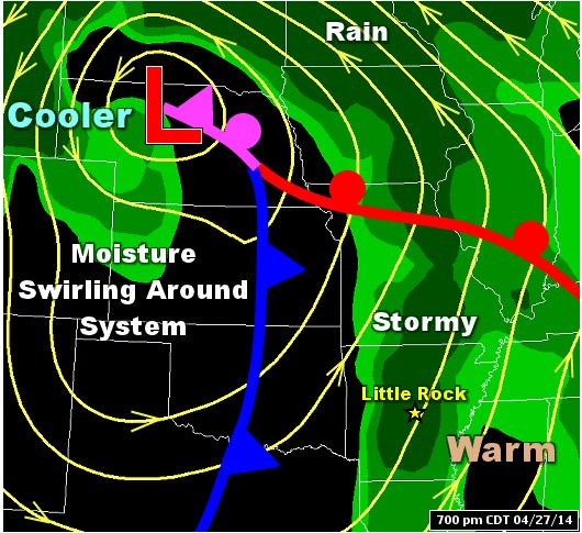
Credit: National Weather Service, Little Rock
Severe weather was expected. In fact, it was forecast with strong tornadoes (at least EF-2 strength) and hail larger than golf balls.
The Storm Prediction Center’s Day 1 Outlook had much of the state outlined in a moderate risk (45%) and parts of central, west and south Arkansas in a high risk (60%).
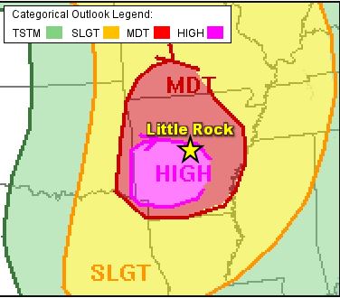
Credit: National Weather Service
As of April 27, 2020, there has not been a HIGH RISK issued for any part of Arkansas since this historic day. In fact, since 1999, there have only been five HIGH RISK days for the Little Rock area.
Around 7 p.m CDT on April 27, 2014, a supercell intensified quickly just northwest of Little Rock in Pulaski County. At 7:06 p.m CDT, a rotating column of air touched down just west of Ferndale in Pulaski County – the tornado was born. For 56 minutes, homes were destroyed, businesses crumbled, trees snapped in half and lives were changed forever. This long-lived tornado traveled 41 miles from Pulaski County through Faulkner County and into White County before lifting near El Paso at 8:02 p.m CDT.
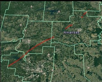
Credit: National Weather Service, Little Rock
The hardest hit areas included Mayflower and Vilonia, both in Faulkner County.
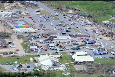
Credit: National Weather Service, Little Rock
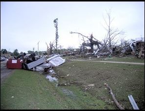
Credit: National Weather Service, Little Rock
The National Weather Service in Little Rock surveyed storm damage for several days. Initially, this tornado was given a preliminary EF-3 rating. It was later determined that the tornado’s strength was moreso related to that of an EF-4. An EF-4 tornado has winds ranging from 166-200 mph. This particular tornado, however, had estimated peak winds of 180-190 mph, making it a high-end EF-4 tornado.
The tri-county, EF-4 tornado killed 16 people and injured almost 200 others. Alone, this tornado killed more people than any other tornado in the United States for the year 2014.
According to statistical data acquired from the National Weather Service, the Vilonia/Mayflower Tornado is:
- the deadliest tornado in the state of Arkansas since the Jonesboro tornado of May 15, 1968.
- the strongest tornado to hit the state since the Denning tornado on May 24-25, 2011 which was also rated an EF-4.
- only the third tornado of EF-4 strength in Arkansas since 2000.
Four other tornadoes occurred in Arkansas on April 27, 2014. They are as follows.
1) Center Hill Tornado in White County. Rating: EF-2. Estimated peak winds: 125-135 mph. Path length: 7.4 miles.
2) The Steprock Tornado in White County. Rating: EF-0. Estimated peak winds: 70-80 mph. Path length: 1.7 miles.
3) The Denmark Tornado in White/Jackson County. Rating: EF-1. Estimated peak winds: 90-100 mph. Path length: 5.3 miles.
4) The Thida Tornado in Independence County. Rating: EF-1. Estimated peak winds: 90-100 mph. Path length: 0.7 miles.


